Recently, I’ve been listening to a lot of Tinariwen, particularly their latest album Hoggar. Tinariwen is a group of Tuareg (Berber ethnic group) musicians in southern Algeria and northern Mali. They are considered founders of “Desert blues”.
They sing in Tamasheq, a variety of Tuareg, which is a Berber language. Some other artists, and albums, that I’ve listened to include these:
I’m trying to make a habit of noting my observations when using the SEPTA system, in the hopes of translating it into some sort of action. I am reading “Hack your Bureaucracy”, and one chapter is on “Be Your Own Customer”. I am already a frequent customer of SEPTA services, but I want to get better about sharing my observations.
I’ve been trying to figure out what my actual theory of change is for my work in transit so here’s my attempt at writing it down.
I know I care about making transit and cities better. But what does that look like?
I’ve been thinking about this question a lot, because it’s hard to actualize without specifics.
Here’s my working theory of change:
I would like to improve transit by:
providing high quality, frequent transit service to transit supportive parcels
making it easier to live in the existing transit supportive parcels (improving access to jobs or lowering the cost of housing)
expanding the envelope of transit supportive parcels
The key word here is “transit supportive parcels.” With this, I recognize that effective transit is really the result of optimal land use. Land use is things like, the density of a parcel, the arrangement of roads, the location of housing and jobs etc. There are many places in the United States, or the world, that just are not conducive to good transit. There are other places that are.
The CEO of Salesforce appeared in an IG reel posted by Bloomberg, where he says that Salesforce has seen productivity increases of 30-50% in key engineering functions, and that AI is doing 30-50% of the work. He also said that he won’t hire any more coders, which implies that productivity gains from AI will allow Salesforce to keep up with growth with the same headcount.
I write (well, not frequently) at both this blog and a substack. I’ve struggled to stay consistent with writing, because I feel a pressure to have my writing stay on one theme. The advice that’s often given to people trying to build an online following is that you should have an idea of the readers you want to reach, and try to keep your content relevant to them.
However, that’s been a challenge for me because I have a wide variety of interests. I’m a curious person, and I just like learning about things. So, today, I’m going to write about a few of the things that have been capturing my interest recently:
French-language YouTube
I have been learning French for a few years. As part of that, I’ve sought out French language media (including videos, podcasts and music) to give me exposure to the language.
It’s been a while since I posted about what I’ve learned or worked on. Here are some things I’ve done since March:
Spatial Data Science: GIS, GeoPandas
A few months ago, I wrote about how I wanted to learn Spatial Data Science. Specifically, I wanted to learn GIS, GeoPandas, GeoJson and PySAL.
Shortly after that, I became the task lead on a project involving a data file at work. The task heavily involved GIS and GeoPandas, and I ended up learning many of the topics that I outlined on the blog post. The only exceptions were network analyses – which I didn’t cover – and buffer analyses and ArcOnline maps with comments – which I got help with. This project was quite expansive – so there’s a lot more to write about in future blog posts.
Beyond the technical analysis, I also created a slide deck (which involved lots of analyses of ridership data) that I presented to our group’s leadership.
I’ve also become the de facto project manager on this task, so I’m picking up some project management and process management skills.
Calanque Sugiton in Marseille, FR. One of the most beautiful places I have ever been
I recently went to France, and was filled with a renewed desire to live abroad, particularly in France. When I was there, I tentatively set myself a goal to live abroad before I’m 30. I’m not being very prescriptive about this – it could be for 2 months, or 2 years, and could be someplace as close as Toronto or as far as Taiwan. But since coming back, I alternate between feeling very confident about that goal, and feeling uncertain about it.
Hesitations about this
I have a lot of worries about moving to France, or just living abroad. Some of this is because I’m a generally anxious person who worries a lot. Some of these might be legitimate concerns. It’s hard to tell.
First, I have some worries about even writing about this publicly. I’m scared that a current or prospective employer might find this, and presume that I’m not sufficiently dedicated to my current role. Or that I’ll commit myself to a course of action without an ability to change it by hitting “Post” on a blog post. Or, I fear that committing to a goal raises the stakes of failure. If I tell my friends I want to move to France, and don’t follow through, it will tarnish my reputation.
Second, I’m scared that this might be a misguided desire or might end up being a mistake, for several reasons.
Spatial Data Science is a field that deals with spatial data – that is, data points that have a geography associated with them. For example, a database of sales by ZIP code would be spatial data. In the planning world, spatial data tends to show up in conjunction with GIS (Geographic Information Systems), the most prevalent of which is ArcGIS (and its open-source equivalent, QGIS).
In college, I worked for a semester at the maps library at the University of Michigan. I like maps, and spatial data, so when I found out about this conference I was excited to see how spatial data was used in industry.
I will have to type up my notes from the conference in a different post, but I’m writing this post because I want to learn more about spatial data science. I’m ~manifesting~ this by writing about it, hoping that it will keep me accountable. Back in 2023, I wrote about GIS being one of the three technical skills I wanted to learn.
Here are some things that interest me about spatial data science, that I would like to learn. I don’t have a plan or goal associated with this yet, because I want to make sure that anything I commit to is realistic (which I haven’t done the greatest job of doing in the past…oops).
I started writing on here back in January, because I was unemployed and needed something constructive to work on. I also enjoyed the accountability and structure that came from publicly writing about my goals, and the satisfaction that came from creating something regularly. When the job search was going poorly (and oh boy was it going poorly in January), it was nice to have something that was entirely in my control and didn’t depend on my resume being picked out of a stack of a 1,000. I was also hoping that if I did some cool stuff on my blog, that I could talk about it in interviews.
But a few things happened that caused my posts to drop off:
I got a job! This is by far the most exciting development. I don’t have as much time to write because I’m working full-time
I wasn’t sure the direction I wanted to take this blog. Do I want this to be professional? Personal? Do I want to make this into something a lot of people read? Is it mostly just for me and whoever wants to ride along? Or do I want to just focus on updating myself and my friends? I felt like it was easier to cut down on posting until I had an idea of the direction I wanted to take
Related to the prior point – someone read the blog! When I started posting on here, I didn’t actually expect anyone to read it. I had a link to this blog in my Instagram bio, and it’s linked on hiddn.co (which is the first result for my name), so it was fair game. But someone I had only recently met called me out on being too hard on myself from things I had posted on this blog, and it made me think about the nature of this medium. Am I too hard on myself (probably)? Or does this blog, which is only a portion of my life, give the impression that I’m too hard on myself (also potentially true)? It made me (over)think about how I present myself on this blog, which made me more anxious about posting.
Anyone who knows me knows that I’m a huge transit nerd. Lately, I’ve been trying to deepen my understanding of transit by challenging myself to work with and analyze transit data. To do that, I’m working on a side project to build a Jarrett Walker style transit frequency map for my hometown transit agency, Chautauqua Area Regional Transit System (CARTS). Ultimately, I’d like to perform a scaled down version of an Operational Analysis, using the Akron bus redesign as a reference. Then, I’d like to use that data to propose updates to CARTS that could help to reverse the trend of declining ridership.
I’ll start by outlining why transit service is important, and then sharing the results of my analysis of frequencies. In the appendix, I’ll share how I arrived at these figures, and my next steps in this project.
2. Background
a. Good transit is important for poverty reduction
First, we need to understand why good transit is important.
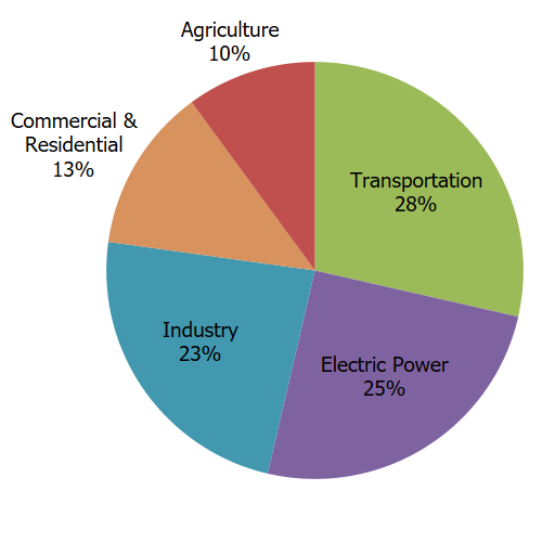
Effective public transportation is an effective way to bring households out of poverty and is a critical method of reducing carbon emissions in a country where transportation is the largest source of carbon emissions.
Total U.S. Greenhouse Gas Emissions by Economic Sector in 2021 Source: https://www.epa.gov/ghgemissions/sources-greenhouse-gas-emissions
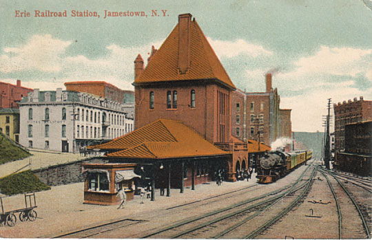
In Chautauqua County, the link between transportation and poverty reduction is quite clear based on a study commissioned by the United Way of Southern Chautauqua County. The study looked at the City of Jamestown, which is the largest city in the county and the anchor of the South County region.