GIS, Excel and More

It’s been a while since I posted about what I’ve learned or worked on. Here are some things I’ve done since March:

Spatial Data Science: GIS, GeoPandas

A few months ago, I wrote about how I wanted to learn Spatial Data Science. Specifically, I wanted to learn GIS, GeoPandas, GeoJson and PySAL.

Shortly after that, I became the task lead on a project involving a data file at work. The task heavily involved GIS and GeoPandas, and I ended up learning many of the topics that I outlined on the blog post. The only exceptions were network analyses – which I didn’t cover – and buffer analyses and ArcOnline maps with comments – which I got help with. This project was quite expansive – so there’s a lot more to write about in future blog posts.

Beyond the technical analysis, I also created a slide deck (which involved lots of analyses of ridership data) that I presented to our group’s leadership.

I’ve also become the de facto project manager on this task, so I’m picking up some project management and process management skills.
Published
Categorized as career

French Dreams

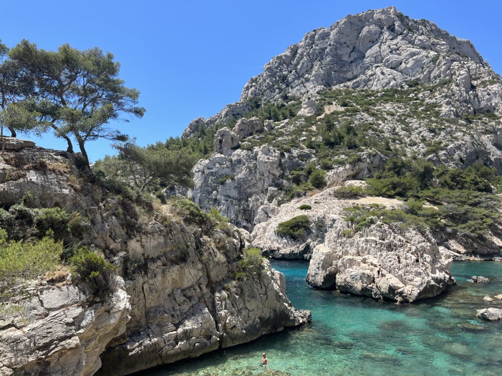
Calanque Sugiton in Marseille, FR. One of the most beautiful places I have ever been

I recently went to France, and was filled with a renewed desire to live abroad, particularly in France. When I was there, I tentatively set myself a goal to live abroad before I’m 30. I’m not being very prescriptive about this – it could be for 2 months, or 2 years, and could be someplace as close as Toronto or as far as Taiwan. But since coming back, I alternate between feeling very confident about that goal, and feeling uncertain about it.

Hesitations about this

I have a lot of worries about moving to France, or just living abroad. Some of this is because I’m a generally anxious person who worries a lot. Some of these might be legitimate concerns. It’s hard to tell.

First, I have some worries about even writing about this publicly. I’m scared that a current or prospective employer might find this, and presume that I’m not sufficiently dedicated to my current role. Or that I’ll commit myself to a course of action without an ability to change it by hitting “Post” on a blog post. Or, I fear that committing to a goal raises the stakes of failure. If I tell my friends I want to move to France, and don’t follow through, it will tarnish my reputation.

Second, I’m scared that this might be a misguided desire or might end up being a mistake, for several reasons. 

2024 Goals

Back in January 2023, I was unemployed and feeling very alone in a Brooklyn apartment that I was subletting from a friend of a friend. The previous summer, I had been laid off from my second job in two years. I opened LinkedIn everyday to news about massive tech layoffs and a slowdown in hiring.

I didn’t know what to do and it felt like I would never get out of that state. In that feeling, I started blogging again and posted this about my 2023 goals.

I meant to do a 2023 goal retro in December, and then a new set of goals in 2024. I never got around to the first one because I got into a relationship, I didn’t get around to the second one because it ended.

But time goes on, and I find myself in need of inspiration – so I’m back. My major goal in 2023 was to find a job. I did that. In 2024, my goal is to get out of the focus on career and job searching and back towards building a life I’m proud of and enjoying it.

Published
Categorized as blog

New interest unlocked: Spatial Data Science

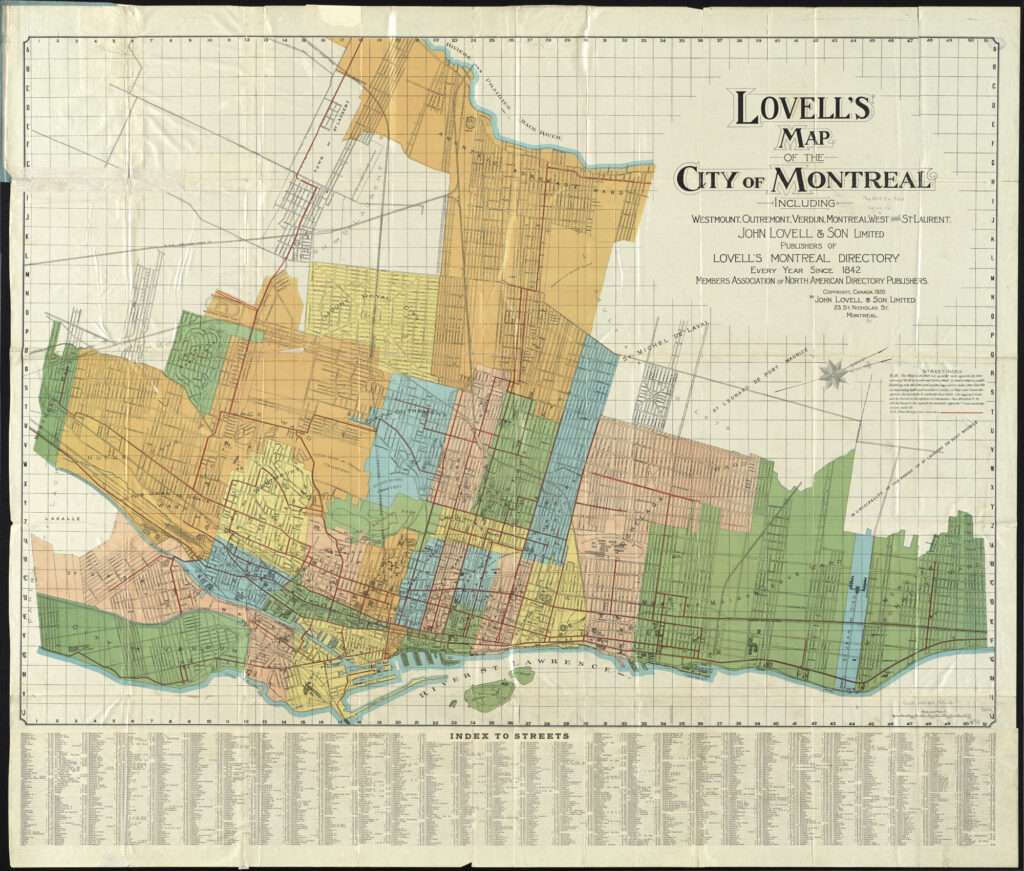
A cool map of Montreal, QC, Canada. “Lovell’s map of the city of Montreal : including Westmount, Outremount, Verdun, Montreal West and St. Laurent” by Norman B. Leventhal Map Center at the BPL is licensed under CC BY 2.0.

A few months ago I attended the Spatial Data Science Conference in New York City, hosted by Carto.

Spatial Data Science is a field that deals with spatial data – that is, data points that have a geography associated with them. For example, a database of sales by ZIP code would be spatial data. In the planning world, spatial data tends to show up in conjunction with GIS (Geographic Information Systems), the most prevalent of which is ArcGIS (and its open-source equivalent, QGIS).

In college, I worked for a semester at the maps library at the University of Michigan. I like maps, and spatial data, so when I found out about this conference I was excited to see how spatial data was used in industry.

I will have to type up my notes from the conference in a different post, but I’m writing this post because I want to learn more about spatial data science. I’m ~manifesting~ this by writing about it, hoping that it will keep me accountable. Back in 2023, I wrote about GIS being one of the three technical skills I wanted to learn.

Here are some things that interest me about spatial data science, that I would like to learn. I don’t have a plan or goal associated with this yet, because I want to make sure that anything I commit to is realistic (which I haven’t done the greatest job of doing in the past…oops).

Things I want to learn about Spatial Data

I’m back – and what is this blog for?

What up doe!

I’m back on this blog after a long hiatus. 

I started writing on here back in January, because I was unemployed and needed something constructive to work on. I also enjoyed the accountability and structure that came from publicly writing about my goals, and the satisfaction that came from creating something regularly. When the job search was going poorly (and oh boy was it going poorly in January), it was nice to have something that was entirely in my control and didn’t depend on my resume being picked out of a stack of a 1,000. I was also hoping that if I did some cool stuff on my blog, that I could talk about it in interviews.

But a few things happened that caused my posts to drop off:

  • I got a job! This is by far the most exciting development. I don’t have as much time to write because I’m working full-time
  • I wasn’t sure the direction I wanted to take this blog. Do I want this to be professional? Personal? Do I want to make this into something a lot of people read? Is it mostly just for me and whoever wants to ride along? Or do I want to just focus on updating myself and my friends? I felt like it was easier to cut down on posting until I had an idea of the direction I wanted to take
  • Related to the prior point – someone read the blog! When I started posting on here, I didn’t actually expect anyone to read it. I had a link to this blog in my Instagram bio, and it’s linked on hiddn.co (which is the first result for my name), so it was fair game. But someone I had only recently met called me out on being too hard on myself from things I had posted on this blog, and it made me think about the nature of this medium. Am I too hard on myself (probably)? Or does this blog, which is only a portion of my life, give the impression that I’m too hard on myself (also potentially true)? It made me (over)think about how I present myself on this blog, which made me more anxious about posting. 
Published
Categorized as planning

Creating a frequency map for my local transit agency, CARTS, part 1 – Analyzing frequencies

1. Introduction

Anyone who knows me knows that I’m a huge transit nerd. Lately, I’ve been trying to deepen my understanding of transit by challenging myself to work with and analyze transit data. To do that, I’m working on a side project to build a Jarrett Walker style transit frequency map for my hometown transit agency, Chautauqua Area Regional Transit System (CARTS). Ultimately, I’d like to perform a scaled down version of an Operational Analysis, using the Akron bus redesign as a reference. Then, I’d like to use that data to propose updates to CARTS that could help to reverse the trend of declining ridership.

I’ll start by outlining why transit service is important, and then sharing the results of my analysis of frequencies. In the appendix, I’ll share how I arrived at these figures, and my next steps in this project.

2. Background

a. Good transit is important for poverty reduction

First, we need to understand why good transit is important.

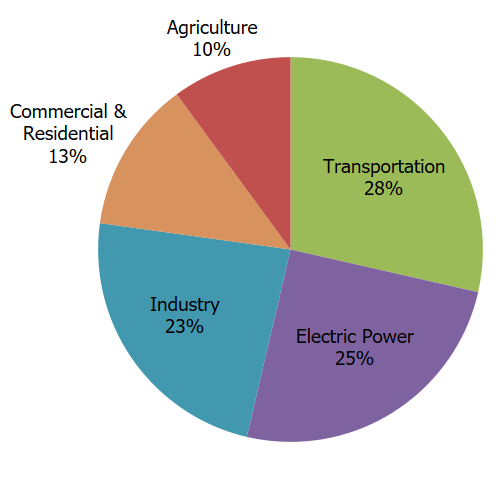
Effective public transportation is an effective way to bring households out of poverty and is a critical method of reducing carbon emissions in a country where transportation is the largest source of carbon emissions.

Total U.S. Greenhouse Gas Emissions by Economic Sector in 2021
Source: https://www.epa.gov/ghgemissions/sources-greenhouse-gas-emissions

In Chautauqua County, the link between transportation and poverty reduction is quite clear based on a study commissioned by the United Way of Southern Chautauqua County. The study looked at the City of Jamestown, which is the largest city in the county and the anchor of the South County region.

Thinking through trip planning, part 3

This is the third part in a series of posts about my month of solo traveling in the fall of 2022. The prior two posts were about my planning process for creating an itinerary. In future posts, I hope to cover my trip, what went well and what didn’t, and what I would change. I also plan on discussing my West Coast trip.

So between publishing that blog post and leaving on the trip, I made some changes. I cut out the Basque Country entirely, and reallocated that time to Andalusía. My reasoning for this decision was as follows:

  • The weather in Andalusía was better than the weather in the Basque country around the time I was traveling
  • I wasn’t particularly inspired by the travel videos that I saw for the Basque Country
  • By cutting it out, I simplified the logistics (less planes, more trains)
  • I was more interested in Moorish / Islamic architecture than I was in modern Spanish culture, and by cutting out the Basque Country, I could spend more time in Andalusía
  • Several Redditors reassured me that there was plenty to do for the amount of time I was planning to be there
Published
Categorized as travel

Breaking down my technical skills goals – Full-stack

Me hacking the mainframe after learning all these technical skills. Source: “Hacker Stock Photo” by devdsp is licensed under CC BY 2.0.

In this post, I talked about the three technical skills I wanted to learn: SQL, Full-stack, and QGIS. In this post, I talked about some things I’ve accomplished. Today, I’m going to break down my full-stack learning goals to hold me accountable.

Course Breakdown and Pacing

This course has 13 parts. Each part is supposed to take around 15-20 hours, or about a week. I’m working part-time until June 9th, so until then I’ll plan on doing one part a week, with a week buffer.

After June 9th, I’ll plan on doing 1.5 parts per week, since I won’t be working and will have more free time.

For Part 1 – 4, I’ll consider each section complete (and will not move onto the next section) after I’ve completed all of the non-starred exercises, as per the course instructions. For the remainder of the sections, I’ll consider a section done when I’ve done 75% of the exercises.

Based on that pacing, here’s what I should accomplish each week:

Technical skill learning update: switching to projects

A few weeks ago, I wrote about how I wanted to learn three new technical skills this year. The reason I want to learn these skills is that I’ve identified roles that interest me that require these skills.

In this article, I’ll share my progress on these goals, the obstacles or I’ve faced, and some solutions I propose to address them.

Q2 Language Goal Update

In January I set some very ambitious language learning goals. I wanted to spend 120 hours this year studying 5 different languages.

By this point in the year, I should have logged 40 hours of language study. As of 1/28, I’d completed ~2 hours of study. Since then, I’ve logged 2.25 more hours of iTalki lessons, and attended two language meet-ups (~3 hours total). I’ll log an extra 2 hours of reading time.

That brings my total up to 9.25 hours. I’m more than 30 hours behind where I should be at this point in the challenge, and I don’t think I’ll meet my goal by the end of the year. In this article, I’ll talk about the obstacles I’m facing, how my understanding of myself has changed, and propose some updates to my goals to better match these changes.