New interest unlocked: Spatial Data Science

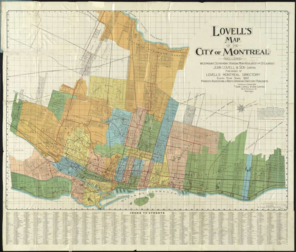
A cool map of Montreal, QC, Canada. “Lovell’s map of the city of Montreal : including Westmount, Outremount, Verdun, Montreal West and St. Laurent” by Norman B. Leventhal Map Center at the BPL is licensed under CC BY 2.0.

A few months ago I attended the Spatial Data Science Conference in New York City, hosted by Carto.

Spatial Data Science is a field that deals with spatial data – that is, data points that have a geography associated with them. For example, a database of sales by ZIP code would be spatial data. In the planning world, spatial data tends to show up in conjunction with GIS (Geographic Information Systems), the most prevalent of which is ArcGIS (and its open-source equivalent, QGIS).

In college, I worked for a semester at the maps library at the University of Michigan. I like maps, and spatial data, so when I found out about this conference I was excited to see how spatial data was used in industry.

I will have to type up my notes from the conference in a different post, but I’m writing this post because I want to learn more about spatial data science. I’m ~manifesting~ this by writing about it, hoping that it will keep me accountable. Back in 2023, I wrote about GIS being one of the three technical skills I wanted to learn.

Here are some things that interest me about spatial data science, that I would like to learn. I don’t have a plan or goal associated with this yet, because I want to make sure that anything I commit to is realistic (which I haven’t done the greatest job of doing in the past…oops).
Things I want to learn about Spatial Data

Creating a frequency map for my local transit agency, CARTS, part 1 – Analyzing frequencies

1. Introduction

Anyone who knows me knows that I’m a huge transit nerd. Lately, I’ve been trying to deepen my understanding of transit by challenging myself to work with and analyze transit data. To do that, I’m working on a side project to build a Jarrett Walker style transit frequency map for my hometown transit agency, Chautauqua Area Regional Transit System (CARTS). Ultimately, I’d like to perform a scaled down version of an Operational Analysis, using the Akron bus redesign as a reference. Then, I’d like to use that data to propose updates to CARTS that could help to reverse the trend of declining ridership.

I’ll start by outlining why transit service is important, and then sharing the results of my analysis of frequencies. In the appendix, I’ll share how I arrived at these figures, and my next steps in this project.

2. Background

a. Good transit is important for poverty reduction

First, we need to understand why good transit is important.

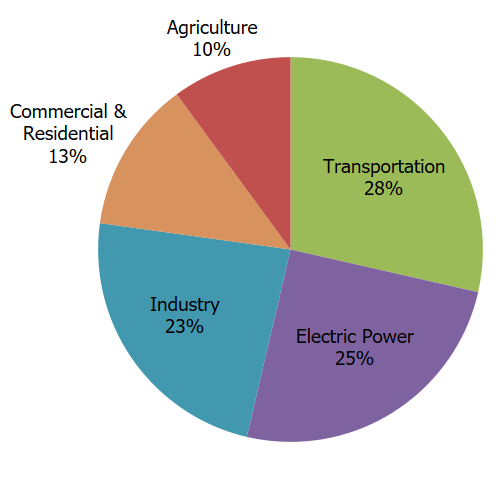
Effective public transportation is an effective way to bring households out of poverty and is a critical method of reducing carbon emissions in a country where transportation is the largest source of carbon emissions.

Total U.S. Greenhouse Gas Emissions by Economic Sector in 2021
Source: https://www.epa.gov/ghgemissions/sources-greenhouse-gas-emissions

In Chautauqua County, the link between transportation and poverty reduction is quite clear based on a study commissioned by the United Way of Southern Chautauqua County. The study looked at the City of Jamestown, which is the largest city in the county and the anchor of the South County region.

Detroit – Hamtramck Assembly

The Dodge Main, or Chrysler Hamtramck Assembly Plant, as it stood in 1965. Image from the Detroit Historical Society.

In 1980, General Motors convinced the cities of Detroit and Hamtramck, Michigan to use a newly passed eminent domain law to demolish 1,500 homes, 144 businesses, and 16 churches to build a new auto plant on the Detroit – Hamtramck Border.

At the time, Detroit was in decline, losing population and businesses to the suburbs. Detroit, and its Mayor Coleman Young, wanted to attract new businesses to the struggling city, and agreed. Despite protests, legal challenges, and a visit by Ralph Nader, the Detroit neighborhood of Poletown was demolished and its 4,200 residents relocated (CityLab).

Want to learn a language that’s useful in the NYC area? Check out these 5

Let’s say you live in the New York Metropolitan region, the area defined by New York City and its surrounding suburbs. You want to learn a language, but you don’t want to learn one to travel somewhere. Instead, you want to learn a language to communicate with people in your region who speak that language. What language should you learn?

I argue that your best bet is Spanish, Chinese (Mandarin/Cantonese), Russian, Korean or Bengali. I argue this based on a combination of three metrics. The first is total number of speakers of each language, the second is total number of speakers of each language who also don’t speak English well, and third is the percentage of each linguistic community who do not speak English well.

File:New York Metropolitan Area Counties Illustration.PNG
New York-Newark-Jersey City, NY-NJ-PA Metro Area (from Wikipedia.org)

The location of Temple #1

Photo credit: Historic Masjid Wali Muhammad

I’m in the middle of reading The Autobiography of Malcolm X, and I’m at the chapter where he moves to Detroit after converting to the Nation of Islam.

Malcolm mentions the NOI’s Temple No #1, citing an address on Frederick St. That wasn’t the Temple’s first address, nor was it the final one. Temple Number 1 now stands at 11529 Linwood Street, in Detroit’s Dexter Linwood neighborhood. Although it’s formally known as Temple Number 1, it is also referred to as Masjid Wali Muhammad [1]. 

Montréal Reflections

I just finished an 8 day trip to Montréal (with 2 days on either end in Toronto). I had some expectations about this trip that I don’t think were met, but still learned many lessons from it that I’ll share today.

My expecations about this trip

This is my second long solo trip. The first one was when I went to Mexico City in February 2020 for 10 days. I went to explore the city, get out of the cold Michigan winter, and see the Monarch Butterfly Preserve. I also wanted to immerse myself in a Spanish speaking environment, and use Spanish. I ended up speaking a decent amount of Spanish to get around, but ended up speaking mostly English with the other people at the hostel.

Hamilton Bikeway

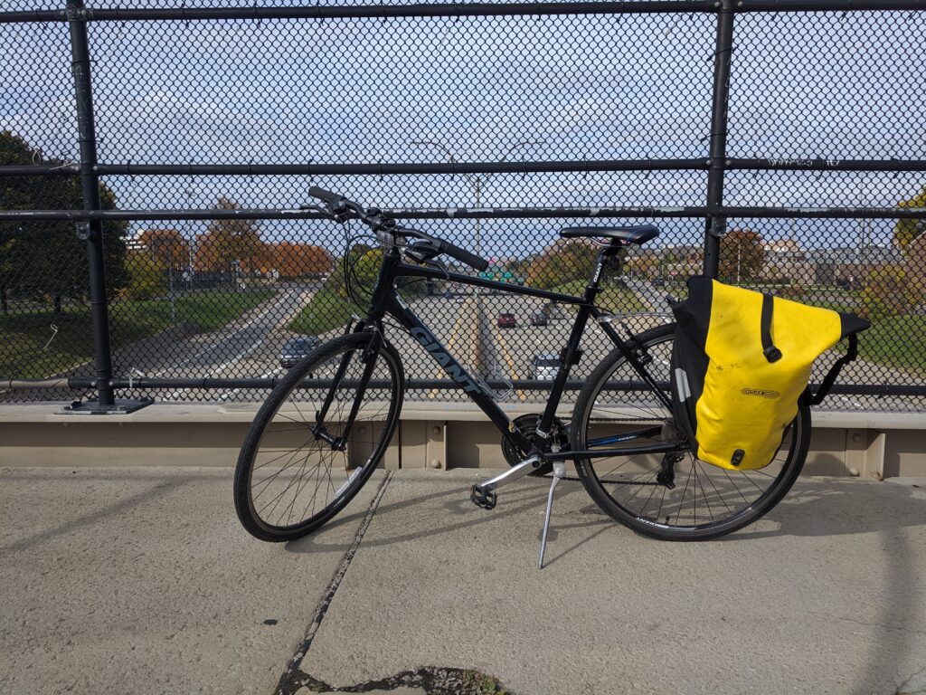
Contrary to popular perception, Detroit is great place to bike. The city’s roadways are engineered for traffic three times larger than the current population, so there are plenty of wide roadways with few cars. Because Detroit follows a grid, there are also plenty of parallel neighborhood streets that can be used to avoid busy roads. On top of that, the city has been investing in protected bike infrastructure, and is beginning construction on the Joe Louis Greenway, a 27.5 mile biking and walking trail.

You can combine roads with protected bike infrastructure and roads that are naturally ideal for cycling (wide road with little traffic) to produce long routes that are low stress. These routes aren’t often marked on maps, and are usually learned through experience. To make it easier for new cyclists, I’m going to outline one of those routes, which connects downtown Detroit to Ferndale. I call it the Cass / Hamilton / Livernois bike corridor, or the Hamilton Bikeway for short.